Having a well on a personal plot is a vital necessity. Even if you have a car, it is extremely inconvenient to deliver water to your dacha in cans and bottles. Digging a well is quite a feasible task, but here you need to arm yourself with knowledge, since you will have to master methods for determining where exactly to look for water and how to correctly position the well shaft in terms of sanitary norms and rules.
How are aquifers located in the ground?
To understand how to find water in a well site, you need to know the basic principles of the location of underground sources. In the thickness of the earth there are waterproof layers that retain water. Thanks to them, the veins cannot sink lower or rise to the surface. The main components of such layers are clay and stones, substances that do not absorb or allow moisture to pass through.
The space between the clay layers, containing clean water, is filled with a sand layer. This layer constitutes the aquifer, which must be reached when digging a well. Moreover, the sand cushion is unevenly located: in some places it is thin, and in others it can reach 10 m. The vein line often breaks and the largest amount of water collects in such places.
There are also places with a curved shape of the clay layer. Here a kind of bowl is formed into which water flows. There is so much of it that these places are often called underground lakes.
Diagram of the location of groundwater in the soil Source ms.decorexpro.com
In order to determine the approximate depth of the aquifer, you can use a special map of the area. However, the information in it can be found very approximate. The exact location can only be determined if you dig a well hole.
Those who are wondering how to find water in a well site themselves should take note that the upper part of the aquifer is already located at a depth of 1.5-2 m. But this will be too polluted water, because due to the proximity of the surface, sewage and untreated atmospheric precipitation. Such sources are suitable only for irrigation and domestic needs.
This layer is popularly called “upper water”. He is extremely unstable. Often during droughts or cold weather, water leaves it. During spring floods, it can flood nearby areas.
It is believed that drinkable water can already be found at a depth of about 15 m, although in practice it is often necessary to dig up to 25-30 m. There is a layer of continental sands that contains pure moisture. At the same time, a fifteen-meter layer of soil ensures complete purification of water from all components that pollute it.
A sufficiently deep well on the site can become a supplier of drinking water Source za.pinterest.com
To what depth can a well be drilled legally?
Although well drilling is done on private property, the resources, which include deep water, are the property of the state.
The permitted depth of a water well is regulated by the following legislation:
- Z No. 2395-1 “On subsoil” dated February 21, 1992;
- Resolution of the Supreme Council of the Russian Federation No. 3314-1 “Regulations on the procedure for licensing the use of subsoil” dated July 15, 1992;
- Instructions for use No. 583 dated April 14, 1994, which regulates the use of the above Regulations.
In accordance with current legislation, it is necessary to obtain a license to carry out drilling operations. If the depth of an artesian well exceeds permissible standards and there is no permit, the violator is subject to administrative punishment in the form of a fine:
- for individuals - from 3,000 to 5,000 rubles;
- for legal entities - from 88,000 to 100,000 rubles.
For directors of enterprises, an individual fine will range from 30 to 50 thousand rubles.
According to the law, everyone who uses wells to obtain water is divided into 3 main categories:
- Individuals extracting water for personal purposes.
- Gardening and dacha cooperatives that carry out commercial activities, but do not violate permissible standards.
- Individual entrepreneurs who operate in compliance with the requirements of the law.
Restrictions on drilling wells without the need to obtain a license:
- Extraction must be carried out from aquifers that are not subject to mandatory registration in the state water register by law.
- Water is not obtained from central water supply systems.
- The daily water flow rate should not exceed 100 cubic meters.
- Water resources are used exclusively for personal purposes and not for business activities.
Obtaining a license is a relatively simple and inexpensive process, but to supply water to a small country house, a well is usually sufficient, which does not require mandatory registration.
Where can you dig wells?
Before looking for water for a well on the site, you need to decide on the places in which the structure can be installed. We recommend that you familiarize yourself with the general rules for the location of wells in order to organize safe and convenient water extraction.
The drinking source must be located at least 25 meters from the epicenters of soil pollution, such as cesspools, landfills, sewers, and street toilets. Otherwise, harmful substances and pathogenic bacteria may enter the well through the water-containing layers.
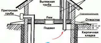
General diagram of a site with a well for drinking water Source syko.ru
The well should be moved 10-15 m away from the buildings to protect the buildings from flooding. At the same time, you also need to pay attention to the objects of the neighboring area.
However, a standard summer cottage plot is 4 acres. At the same time, it is always densely planted and built up and there is a problem with compliance with standards. In this case, you can move it to a distance of only 5-7 m from the house or outbuilding.
These rules apply to shaft-type wells. Deep wells require an even greater distance from buildings and contaminated areas.
Those who are interested in how to find a place for a drinking well should remember that it is better to avoid:
- places subject to frequent flooding;
- wetlands;
- areas adjacent to highways.
Using this principle, you can place wells of varying depths Source domotheme.ru
See also: Catalog of house projects for permanent residence
If the soil in the area of the planned well is clayey, then the risk of flooding of the site is noticeably reduced. But at the same time it is necessary to organize careful insulation of the walls of the structure. You can dig special frame rings made of asbestos into the ground. This will protect the water from contamination associated with melting snow and precipitation.
What sanitary requirements may apply to the location?
These rules were developed by the country's chief government doctor, Onishchenko:
- do not install in areas where landslides and other types of soil deformation may occur;
- retreat at least 30 meters from a busy highway with heavy traffic;
- avoid areas with active or closed chemical storage;
- check the surrounding area for possible sources of microbial contamination.
How to find water on the site: working methods
Below we will describe various methods for finding water for a well. All of them have a scientific basis and have proven themselves well. Therefore, we advise you to pay attention to the following points:
- Fog. To use this method, you need to get up early in the morning and inspect the area. In some places there will be a slight, barely noticeable haze above the ground - something like fog. This indicates the location of aquifers close to the surface. At the same time, you need to understand that if the cause of the fog is moisture escaping from the soil, then it will rise in clouds upward and then settle near the ground.
- Behavior of insects and animals. This method requires maximum observation. For example, horses, when looking for water, begin to hit a place with high humidity with their hoofs. Dogs in hot weather reduce their body temperature by digging holes in wet soil and lowering their heads into them. In the evening, mosquitoes swarm where there is more evaporation from the ground. Mouse holes are never found in places with shallow water-bearing veins. At the same time, ducks, geese and swans always lay eggs above underground springs.
Strange behavior of animals may indicate the presence of underground sources Source m.yukle.mobi
- Plants. Places with shallow water carriers can be found by the presence of some representatives of the flora. Thus, the proximity of the vein is evidenced by the lush growth of coltsfoot, sorrel, and hemlock. Nettle always grows in fairly moist soil. In the driest places, moisture-loving plants are not found. Pines are always found where the water is quite deep.
- Glass jars. For such an experiment, you need to place glass jars around the entire area in the evening, neck down, and leave them until the morning. In the morning, the dishes located closest to the aquifer will have more condensation than others.
Groundwater conditions
According to the conditions of occurrence, the following types of groundwater are usually distinguished:
Verkhodka waters
. Verkhodka is underground water that lies at a shallow depth in the aeration zone - the zone of free penetration of air. Typically, perched water does not have a continuous distribution, but forms relatively small lenses that are underlain by water-resistant rocks (Fig. 23). The thickness of such lenses of perched water usually does not exceed 0.5-1 m, less often it reaches 2-3 m. Here the water is already in gravitational form and has a level. The water level of perched water is subject to significant fluctuations, which explains its disappearance in wells in areas with arid climates.
Groundwater.
Atmospheric waters, seeping from top to bottom to the aquitard, and then moving horizontally, gradually fill all the voids in the rock. This is how aquifers arise (Fig. 23).
aquifer
called a layer or layer of rock in which the pores, voids and cracks are filled with water.
Each such layer has a roof and a base. If the formation is not completely filled with water, then the aquifer refers to only its water-saturated part. The first permanent aquifer from the earth's surface is called the groundwater horizon
.
Groundwater has a free surface - a mirror
, or
groundwater level.
This level is not constant. It usually rises during rainy periods and decreases during dry periods. If the groundwater level in some area rises to the earth's surface, a swamp forms here.
In general, groundwater is characterized by the presence of a free water surface - a level, the presence of only one, underlying, aquifer, and the absence of pressure.
Interstratal (formational) waters
. The difference between interstratal waters lies primarily in the fact that they are contained between two aquitards, that is, they are limited by them both from above (from the roof side) and from below (from the bottom side). Aquifers containing interstratal waters are usually characterized by a wide distribution area, often measured in thousands of square kilometers. Moreover, they lie at a considerable depth, emerging to the surface only at the periphery.
Groundwater together with its host rocks form hydrodynamic systems
, which are divided into non-pressure and pressure.
Gravity
hydrodynamic systems are usually characteristic of groundwater basins that do not have natural pressure.
Within pressure
systems, atmospheric water enters the permeable formation in areas where it is exposed at the surface, in the so-called
recharge area .
Gradually, atmospheric moisture penetrates deeper and completely saturates the entire layer.
Moving along the formation, water reaches other areas where it comes to the surface and flows out on its own, forming sources of groundwater. This is an area of discharge
, or
drainage
of formation water. Depending on the relief and altitudinal position of the feeding and unloading areas in the central, most deflected part of the basin, conditions may exist that are favorable for creating pressure, i.e. spontaneous outpouring of water under pressure (Fig. 24, a).
Thus, in the central part of the basin an area is formed
pressure within which water from wells can flow out in the form of a fountain. The height of water rise depends on the location of the wells relative to the feeding and drainage areas and on the hydrostatic level.
Hydrostatic (piezometric) level
called an imaginary surface passing through the area of feeding and discharge and determining the height of the rise of water in a given place (Fig. 24). Piezometric level is usually expressed in absolute terms relative to sea level. Artesian water cannot rise above this level when gushing.
Another characteristic of the pressure area is hydrostatic (piezometric) pressure
, which is understood as the height of the water column from the top of the aquifer to the piezometric level. Piezometric head is expressed in meters.
Video description
Here is a video describing this method of finding water:
- Brick and salt. The method is based on the fact that these substances absorb moisture well. However, the soil must be completely dry. Here's how to determine where to dig a well on a site: pour salt or crushed brick into a clay pot, weigh it and record the mass. Then the vessel is wrapped in gauze and buried half a meter into the ground. A day later, the pot is dug up and weighed. Too large an increase in mass indicates the proximity of an aquifer.
Using table salt you can search for aquifer veins Source sakadangkuya.com
- Barometer. If there is a body of water near the site, you can use a classic aneroid. The fact is that the pressure increases by 1 mm. Hg Art. when lowered every 13 m. The aquifer will lie at approximately the same level as the natural well. And in order to determine the approximate depth of an underground source, you need to measure the pressure on the shore of the reservoir and at the site of the proposed digging, and then, based on the difference in readings, calculate the height difference.
- Wells in neighboring areas. If a neighbor has built a working well or well near the border of their yards, then there should be water on your property. You can ask how deep the mine is and what kind of rocks are encountered along the way. This way you can collect the necessary hydrological data and plan your work.
You can contact your neighbors for the necessary information Source m.fishki.net
But the most accurate and reliable way to find water on a site for a well with your own hands is exploratory drilling. It is advisable to choose a place to work based on all the methods described above. It is necessary to drill a small diameter well with a depth of 7-8 m. For this, you can use the most ordinary drill. If an aquifer is discovered, you can start digging a well.
Digging methods
There are two technologies used to dig a well. Both methods are used, just at different depths. And both have their drawbacks.
Alternate installation of rings
The first ring is placed on the ground, which is gradually removed from the inside and under the side. Gradually the ring lowers. There is a very important point here: you need to make sure that it goes straight down, without distortions. Otherwise, the shaft will turn out to be inclined and, sooner or later, the settlement of the rings will stop.
To avoid skewing, it is necessary to control the verticality of the walls. This is done by tying a plumb line to a block and placing it on a ring. Additionally, you can control it at the top level.
Tools needed for digging a well
When the upper edge of the ring is level with the ground level, roll the next one. It is placed strictly on top. The work continues. If on the first ring the soil can be thrown over the side with a shovel with a shortened handle, then on the next ones you have to remove it using a gate or a tripod and a block. In this way, at least two people must work, and at least three, or even four, are needed to move the rings. So it is impossible to dig a well yourself, with one hand. Unless you can adapt a winch.
So, gradually, the depth of the well increases. When the ring is lowered to the ground level, a new one is placed on it. To descend, use driven brackets or ladders (more correctly, brackets).
The advantages of this method of digging a well:
- You can check how tight and even the ring has become.
- You can lay the same rubber gaskets that will ensure tightness or place them on the solution.
- The walls do not crumble.
These are all advantages. Now about the cons. Working inside the ring is inconvenient and physically difficult. Therefore, using this method, they dig mainly to a shallow depth - 7-8 meters. Moreover, they work in the mine in turns.
The structure of the “knife” for easier penetration of soil when digging wells
One more point: when digging a log with rings, you can speed up the subsidence process and facilitate the passage of soil using a knife. It is made of concrete and is poured into the ground at the very beginning. To form it, dig a groove in a circle. In cross-section it has a triangular shape (see picture). Its inner diameter coincides with the inner diameter of the rings used, the outer diameter is slightly larger. After the concrete has gained strength, a “standard” one is placed on this ring and work begins.
Installation of rings after reaching the aquifer
First, a shaft without rings is dug. At the same time, they watch the walls. At the first signs of shedding, they place rings inside and continue to deepen using the first method.
If the soil does not crumble along its entire length, when it reaches the aquifer, they stop. Using a crane or manipulator, rings are placed into the shaft. Then, they deepen it a couple more rings using the first method, increasing the flow rate.
First they dig a mine down to the aquifer, then they put rings in it
The technique for excavating soil is the same here: as long as the depth allows, it is simply thrown out with a shovel. Then they put up a tripod and a gate and lift it in buckets. After installing the rings, the gap between the walls of the shaft and the ring is filled up and compacted. The top few rings can be sealed from the outside (with bitumen impregnation, for example, or other coating waterproofing).
When working, control of the verticality of the walls is also necessary, but it can be adjusted within certain limits. The control method is similar - a plumb line tied to a block and lowered into the shaft.
Advantages of this method:
- The shaft is wider, it is more convenient to work in it, which allows you to make deeper wells.
- Several upper rings can be sealed externally, which minimizes the possibility of the most contaminated water entering.
There are more disadvantages:
- It is difficult to check the tightness of the joint of the rings: it is prohibited to be in the shaft during installation. It is impossible to move an already installed ring in it. It weighs hundreds of kilograms.
- You can miss a moment, and the mine will crumble.
- The filling density of the gap between the shaft wall and the rings remains less than the “native” soil. As a result, melt and rainwater will seep deeper, where they will get inside through the cracks. To avoid this, make a protective circle around the well made of waterproof material (waterproofing membrane) with a slope away from the walls of the well.
Searching for water using a wire or vine
The use of aluminum wire and wicker is another well-proven technique. Frames have been used to find water since ancient times. The operating principle of such devices is based on the phenomenon of dowsing and the properties of the magnetic field.
This is how you can find water in your area Source ms.decorexpro.com
Concept of groundwater regime
Groundwater regime is a time-regular change that occurs in the aquifer as episodic, daily, seasonal, annual, long-term and secular fluctuations in connection with meteorological and geological processes. The concept of the regime of groundwater covers all aspects of its activity and properties: temperature, physical state, nature of water exchange, level (pressure), flow rate, chemical and gas composition, etc. The regime of groundwater can be very variable (overwater), unstable, depending on episodic climatic factors (upper horizons of groundwater), constant (lower horizons of groundwater), very constant (artesian waters).
Video description
We recommend studying this video describing the use of an aluminum frame to search for water:
Now about how to search for water for a well using a vine. As an indicator, you can use a section of a branch of any tree with a fork, the angle of which is approximately 150°. The branch is thoroughly dried in the sun, and then taken by hand by the two ends so that the central main part is directed forward. Then with such a “device” they walk around the site. Close occurrence of aquifers is possible in those places where the trunk tilts towards the ground.
Dowsing gives the most accurate readings at certain time intervals:
- from 6 to 7 am;
- from 16 to 17 hours;
- from 20 to 21 o'clock;
- from midnight to one in the morning.
Few people know how to correctly determine the location of an underground source using a vine. Source bastanshenas.com
Although the vine and aluminum provide fairly accurate information about the presence of water, the source may turn out to be just perched water. Therefore, in any case, immediately after discovering areas with high humidity, exploratory drilling should be carried out.
Briefly about the main thing
Water is located underground between layers of water-resistant substances. Most often, these substances are clay and stones.
Water in underground springs is contained in a layer of sand, which has different thicknesses in different places.
Water accumulates in large quantities where the waterproof layer forms a kind of bowl.
Wells must be built away from landfills, sewers, roads and at a distance from buildings.
To find water in an area, you can watch the evaporation of the earth or the behavior of animals and insects.
To search for water in the area, you can use salt, glass jars, a barometer, aluminum wire or a vine.
It is better to carry out exploratory drilling in the places where the aquifer vein is supposed to occur.
Ratings 0