Drainage pond
In swampy areas, measures to lower the groundwater level are quite complex - you will need the help and participation of neighboring property owners. To understand the meaning of reclamation work in a wetland, let’s look at how a swamp is formed. This is usually a consequence of lakes being overgrown with sphagnum moss (Fig. 1). It follows that if you make a wide reservoir, it will serve as a reservoir not only for draining melt water, but also for unloading groundwater. The wide surface of the reservoir will evaporate moisture and thereby draw water from the soil. The reservoir is located in the lowest place of the land plot or beyond.
Difference from perched water
Verkhovodka is a local accumulation of groundwater located above the groundwater level. This is due to the seasonal factor and is temporary. This is precisely what makes it different.
During certain periods (for example, heavy rains or heavy snowmelt), this phenomenon is noticeable and noticeable, and during the dry period, it almost completely disappears.
The groundwater level is also subject to slight fluctuations, but not so significant, and this layer cannot completely disappear.
There is no high water on slopes and sandy areas, because in these cases there are opportunities for its natural removal.
Symptomatic treatment: pumping, drainage, water removal
Groundwater pumping
The power of the drainage pump must be selected at the rate of 0.5–1.3 m3 per square meter of area of the drained area. This means that from the basement of a 100 m2 house you will have to pump out from 50 to 130 m3 of water, provided there is no incoming moisture.
Surface drainage
It is implemented by an open trench up to 1.5 meters deep, the task of which is to overcome the folds of the waterproof layer and direct the water towards the natural slope of the soil. Very large areas can be drained in this way, up to several blocks of a cottage community, so land owners often unite and hire equipment to dig trenches.
Land reclamation measures
Typically, flood-prone areas are located on the outskirts of populated areas in natural lowlands and folds of the terrain. In these cases, the water flows along a natural slope, and the trench is directed towards the lowest point and has a constant depth.
In cases where the border of a populated area is far away or the landscape of the area precludes the discharge of water into a lowland, the same drainage ditch is used, but with an artificial slope. It carries water from an area oversaturated with moisture to a less saturated area, where it is absorbed into the soil as it flows.
Such activities cannot be carried out without geodetic leveling; geological surveys are also required to extract the detailed topography of the impermeable layer. Add to this the costs of mechanized excavation and installation of trench passages under roads.
Cost table for groundwater drainage along an artificial slope
| Topographic survey of the area M 1:500 | 500-600 rub./0.01 ha |
| Probing the soil and drawing up a topographic map of the aquifer layer | from 2000 rub./1 ha |
| Drainage system design | from 20,000 rub. |
| Excavator services | 1000-1500 rub./1 hour (5-12 meters) |
| Foreman services | RUB 3,000/shift (8 hours) |
| Cost of embedded pipes | 1100-1300 rub. for 1 linear m |
The construction of such a trench will allow up to a hundred areas to be drained and the same number will be able to connect their drainage to the general discharge system. So if you divide the costs by the total number of participants, the amount will be quite reasonable. The budget can be cut if excavation work is done manually, for example, by members of a dacha cooperative.
Such measures only provide a general improvement in the geological situation; local flooding will have to be eliminated by additional measures.
How to determine the proximity of occurrence
There are several tricks to determine the proximity of water.
- Look in and assess the condition of the well and the water level there (if there is one, of course). For reliability and accuracy of measurements, it is recommended to use string or tape measure.
- Reeds and nettles like to settle on damp soil; if they are present, it can be assumed that groundwater is somewhere at a level of 2 meters from the surface.
- A dry area with abundant green shrubs may also indicate a high water level.
- Partial fogs in the morning.
- Lack of anthills.
Peak moments of humidity occur in spring, at its earliest period, then the necessary measurements are made.
What it is?
First you need to define the concept. Groundwater is the upper layer of water from the surface of the earth.
Their level is high if they lie at a depth of up to two meters from the ground surface. This is not difficult to determine.
It is enough to drill a well a couple of meters deep with a hand-held garden drill in several places on the site and wait a day or two. If the level is high, the well will inevitably fill with water.
This needs to be done in the spring, since it is then that groundwater is closest to the surface due to intense snow melting.
If the drilled well is dry, then there are no problems , you can calmly lay the foundation for the house or lay communications. If water is visible, it is better to wait a while and first artificially reduce its level by installing drainage.
What is groundwater
This is the water that collects in several layers of soil. The occurrence can be quite far from the surface and not cause any problems to the owner of the site. But when groundwater comes very close, instead of a well-kept garden, you end up with a swamp or a small lake, and constant dampness reigns in the house. The amount of underground reserves is directly affected by precipitation; it is only at first glance that it seems that it has rained and everything has dried up. Moisture tends to accumulate and turn into streams or lakes.
Main types of water:
- Local waters - this means that their depth is approximately 0.5-3 meters. Most often they are located in depressions between layers of soil, disappearing in frost or heat. Replenishment of the reserve occurs during the rainy season or in the spring, when the snow begins to actively melt.
- Gravity waters - depth from 1 to 5 meters, are characterized by a constant nature and are fed from all available sources: springs, wells and other nearby bodies of water. It is unpressurized groundwater that causes the most problems, but it can be removed with a special drainage system.
Protection of wells and wells from groundwater
Groundwater, in addition to being capable of causing damage to pipes and concrete rings, can significantly affect the quality of borehole and well drinking water. Groundwater contains a large amount of dissolved active substances that can accelerate the rate of metal corrosion by an order of magnitude, as well as small silty and mechanical impurities that heavily pollute the water.
There is a whole range of measures that allows you to maintain water purity and extend the life of the equipment:
- The wells are protected with caissons and conductors. They are installed to the depth of the lower boundary of the waterproof layer, thereby blocking the path of groundwater. The cost of installing a caisson or conductor ranges from 5 to 11 thousand rubles per meter of depth.
- In some cases, digging in the immediate vicinity of a storage well for collecting and pumping groundwater helps. Due to this, you can drain the nearby area and obtain an additional source of process water.
- You can also install a protective lock around the well. A simple filling of a dome of compacted clay will divert high water and groundwater from the adjacent area from the well.
Where are they used?
This resource is widely used to meet household needs. In each settlement, a shallow mine is dug near the house to use water in the kitchen and for watering plants. Due to strong differences in taste, housewives prefer to take moisture for cooking from certain points. That is, the chemical composition can be different even on the same street.
In industrial quantities, use is limited due to seasonal level changes and low power. In most cases, the amount of dissolved impurities does not meet the standards. In addition, overly active exploitation can disrupt the natural water balance, and thereby affect the nature of vegetation in the area, since part of the flora receives nutrition from great depths.
Raising the site level
Additional backfilling of the soil layer can help with high occurrence of perched water and soil infiltration of water from a neighboring reservoir. Considering the amount of work, this is a rather expensive method, but in some cases the most effective. Especially when neither surface nor deep drainage, due to the geology and location of the site, will give a noticeable effect. This method is also used when the problem is local in nature, and it is not economically feasible to install a full-fledged drainage system.
Filling is done before construction or in the case when the construction site lies away from the wetland. There are several scenarios for draining additional soil backfill:
- The problem area on the site is local in nature, the soil level needs to be raised slightly - no more than 30 cm. In this case, you can fill in imported fertile soil and plant moisture-loving shrubs and herbs.
- The swampy lowland on the site is local in nature, but it requires backfilling of soil with a height of more than 30 cm. In this case, backfilling is carried out in three stages. First, remove the top layer of fertile soil (if it has value). Level the area with inexpensive drainage materials - recycled crushed stone, crushed bricks, quarry sand. Then return the soil to its place.
- Most of the site is swampy. A deep drainage system is being installed. Then, depending on the required height of the level, a layer of soil or a layer of drainage material and soil is poured.
In conclusion, it is worth mentioning one more method of drying. In fact, this is one of the types of deep drainage, but without pipes. In its modern version, it is called “soft drainage” - geotextiles are laid in trenches with access to the walls, crushed stone is filled in and the edges of the textile are wrapped around it.
But soft drainage copied a long-known folk method that our ancestors successfully used. They used ditches as a water conduit, in which they laid bundles of long brushwood, and covered them with a mixture of crushed stone and sand.
Our expert's advice:
dizlandshafta
Helpful20Useless2
Purity
Recently, people have begun to think about the quality of water in the upper layer at the state level. Due to the high intensity of economic activity, the most exotic pollutants penetrate into the springs. As a result of the work of agricultural enterprises, fertilizers, pesticides and decomposition products from farms enter it. Industrial pollutants are considered more dangerous, since they are difficult to process naturally and contain salts of heavy metals. One of the problems is the presence of protozoan microorganisms and viruses. Thanks to organic matter and oxygen, water from wells and springs has a large number of bacteria.
The process of concreting and waterproofing the foundation
When pouring it yourself, it is not recommended to rush and pour large volumes of cement mixture into the formwork. The best option is to pour the composition in layers, as it requires careful compaction. It is performed using a piece of reinforcement that is used to pierce liquid concrete. This allows the air to be expelled from it. It is advisable to pour the next layer when the previous one has set sufficiently and forms a fairly durable surface.
https://youtube.com/watch?v=Pa_pg9S1kRg
After completing the work on forming the tape or slab, they must be protected from drying out and being washed away by rain. Therefore, in the first days, the concrete is watered with water from a hose, and at night it is covered with water-repellent material.
When it is finally ripe, the formwork is dismantled. Next, all sides of the foundation are coated with bitumen or other waterproofing compound. Sheets of roofing material are laid on the surface of the slab or tape, which will serve as a cut-off waterproofing for the lower frame of the building.
We will install drainage channels in the future garden
A whole network of drainage channels is needed, they should literally encircle the area, you can even throw bridges over these channels and move along them to the main place, which will gradually drain.
Before constructing drainage channels, you need to determine which way your site slopes. After determining, try to make sure that the channels are directed exactly towards the slope. After digging them, be sure to cover them all with thick plastic film; it will protect the channels from overgrowing. Ultimately, all the channels should converge in one place, forming something like a pond, which will serve as an evaporator of excess moisture. It will be possible to draw water from it for irrigation.
If it is not possible to build a drainage pond, then at least make a drainage well, also directing all the channels from the site into it. But in this case, you will have to use a pump, which from time to time will need to pump out water from the site, draining the well.
Planting vegetation
You can plant moisture-loving trees on the site. It is necessary to choose plants with fibrous roots - willow, birch, maple. Decorative hedges made of shrubs will also help. Hawthorn, rosehip, serviceberry, and spirea are suitable. You can also grow beds with cranberries, viburnum or blueberries.
Often the opposite task arises - to remove plants that grow in such an area. We are talking about sedge and reeds. It will not be enough to drain the area; it is necessary to remove the powerful root system. To do this, the soil is opened to great depth. Then you will need to remove all the roots and fill the hole with roofing felt.
These methods have varying degrees of effectiveness and are often used in combination. If the problem cannot be resolved with your own hands, then you should hire specialists who will quickly pump out the moisture. However, over time the problem may return.
General information
The principle of operation of drainage on the site
The presence of a drainage system on the land plot of a country house increases the level of comfort while living in the house. Drainage protects the basement floors from dampness, the formation of cracks on the building, and paved paths, which guarantees the preservation of the landscape design on the site unchanged. It is possible not to lay drainage in rare situations.
What determines the need for drainage:
1. drainage is laid to drain water from the base of buildings. If water comes very close to the foundation, then the soil can shift and the house can “float.” This phenomenon can be found in clayey areas. If you add soil freezing to this, frost heaving may occur, as a result the house may be squeezed out of the ground.
2.drainage protects basements from flooding. With better installation of waterproofing layers, moisture will still penetrate into the house if there is a lot of it. Mold and mildew grow quickly in damp basements. Rain and snow, combining with salt solutions from the soil, are aggressive substances that corrode the structure of the foundation and walls.
3. If there is drainage and high groundwater levels, the septic tank is not in danger of being squeezed out of the soil.
4. Drainage and storm sewer together will quickly remove water from the building, preventing it from seeping underground to the foundation.
5.Drainage maintains the soil at optimal moisture; puddles will not form on the ground.
6.Abundance of water in the soil will lead to rotting of tree roots.
7. If the site is inclined, then with heavy rainfall and floods the upper fertile soil can be washed away. The water will go deep through the drainage and the soil will not be washed away.
In what situations does drainage require construction?
There are cases when the need for drainage construction is not questioned. Under what circumstances is the drainage structure shown:
1. When the site is located without a slope, drainage is required. If there is a lot of precipitation or a lot of snow melts, the water will not flow down the slope, it will stagnate in the form of puddles.
2. When the site is located in a lowland, drainage is required, because all the water will accumulate on the site, running down the slopes.
3. If the site has a strong slope, drainage is required, because water, quickly flowing down, will take with it the upper black soil layer. This flow of water should be directed deep into the drainage system.
4.If there is a clay type of soil, drainage is required because soils have low drainage capacity. Water will stagnate on the surface without penetrating into the deeper layers.
5. When water occurs underground above one meter, drainage is needed.
6. If the foundation is located too deep, close to the flow of groundwater, then with a seasonal rise in water, the base may flood.
Attention! The drainage system should be planned at the design stage. 7. When covering a large part of the area with concrete, tiles, or a lawn that has an irrigation system, drainage is required. 7. When covering a large part of the area with concrete, tiles, or a lawn that has an irrigation system, drainage is required
7. When covering a large part of the area with concrete, tiles, or a lawn that has an irrigation system, drainage is required.
In most cases, a drainage system is vital. Before its construction, you should study the properties of the soil on the site.
How to correctly calculate the drainage of a site according to SNiP?
When constructing and calculating drainage on your site, it is recommended to follow the requirements of the relevant regulatory documents.
In relation to the topic of the article, you need to pay attention to SNiP (an abbreviation for Building Norms and Rules) 2.06.15-85 “Engineering protection of the territory from flooding and flooding”, as well as SP 250.1325800.2016 “Buildings and structures. Protection from groundwater."
SNiP clearly defines all stages of drainage creation:
- Project in which system data should be specified:
- general scheme.
- geometric data: trench parameters, their slope, distance between system elements.
- diameters of pipes used, parameters of wells.
- fasteners, materials for filling drainage trenches and pipes.
- Cleaning the area where drainage will be laid.
- Digging trenches taking into account how much the soil freezes in a particular area.
- Strengthening walls with gravel or polymer materials
- Laying of pipes, if used, taking into account the permissible material, as well as the laying depth in accordance with SNiP.
- Digging drainage wells or septic tanks, calculating the permissible angle relative to ditches or closed drainages.
Site flooding problem
Spring floods, heavy melting of snow, or even problems with the water supply can cause a real flood in the country. Sooner or later, everyone who has chosen a site near a reservoir faces the following problems:
• there is water on the site; you can even sail a boat;
• the soil is swampy and collapses underfoot;
• water in the cellar up to the ceiling.
• There is dampness all around the house, the floor and walls are covered with stains.
If the area is poorly drained, melting snow can cause flooding
In such a situation, it is already too late to think that good soil drainage, properly organized drainage ditches, or timely snow removal on the site could save a lot of problems. In case of severe flooding, you will have to prepare for a systematic and lengthy process, which will take at least three months and is carried out in separate stages:
• drainage of the territory;
• removing water and drying the cellar;
• removing moisture from the house;
• putting buildings and homes in order.
Determination of groundwater level
There are many terms used by surveyors to refer to groundwater, and one of them is site groundwater map or groundwater zonation. If you have such information, it will be much easier for you to arrange your own site, and you will be able to easily understand whether the site needs to be drained in certain places, backfilled, where you can build and where you should not plant even plants with a shallow root system.
Unfortunately, in our time, such geological studies are quite expensive procedures that require the conclusion of contracts, waiting in line, and certain costs. But there are always smarter ways to get the necessary information that will help in the future.
We are looking for the groundwater level on our site
How to determine the groundwater level on a site in order to decide in advance the issues of building construction and planting? For the greatest correctness of the information obtained during the determination processes, it is recommended to use effective methods in the off-season, when the amount of precipitation is maximum. This is spring or autumn, with melting snow or frequent rains, respectively.
Geobotanical method for determining groundwater level
Here it is worth working hard and paying attention to the consistency of the growth and development of plants depending on the water level and some features of the area. For this purpose, special tables are used, which include plants that are most common on certain soils and that develop differently on soil with varying degrees of moisture.
The method is quite interesting, but difficult for beginners, and the worst thing is that it can take a lot of free time, which is often not enough.
How to determine the groundwater level in a simple way?
Checking the water level in wells
The groundwater level, or rather even the seasonal fluctuations in levels, can be determined by the marks inside the well. Such marks are always present, since water leaves a certain mark on concrete. It is necessary to determine the highest point, the water level at the time of testing, the level at the time of hot weather in the summer, and also note how far these levels are from ground level. It is also a complex job, which is not always clear to beginners in geological exploration, even if it is an amateur one. But the method is in demand, especially when everything needs to be done quickly and inexpensively.
Checking the groundwater level using wellsDrilling a well to determine groundwater level
The fastest and easiest way from all aspects, except technical. But if the farm has a simple drill for the earth, or it is available as an attachment on your mini-tractor or even a tractor, then everything becomes much simpler.
It is necessary to drill a well in the soil at least two meters deep and monitor it for 3-5 days. If water gradually rises at the bottom of the well, this may be an alarm bell and mean that the groundwater level is high and may increase with precipitation. But if after 3-5 days the well is dry, then there is nothing to fear. In large areas, it is customary to drill more than one well in order to accurately determine where water may be present, and where it will definitely not cause any problems.
Sometimes, to install a groundwater treatment area, it is necessary to make several wells
SGround.ru
How does groundwater affect foundations?
Table of contents
- Introduction
- The influence of groundwater on the properties of foundation soils
- Aggressiveness of groundwater
- Aquifers and perched water
- Ground water level
- Maximum forecast (calculated) groundwater level
- Capillary rise of groundwater
- Artificially lowering groundwater levels
- Conclusion
- Related Articles
Introduction
As already noted in other articles concerning frost heaving of soils, the proximity of the groundwater level to the freezing front has a decisive influence on the heaving processes. But groundwater is dangerous not only for this - in the warm season, soaking also causes a sharp decrease in the physical and mechanical properties of soil compared to a dry or moderately wet state. And for the structures themselves, groundwater is not the best neighbor, let’s figure out why.
The influence of groundwater on the properties of foundation soils
All cohesive dispersed soils (loams, clays, sandy loams) deteriorate their physical and mechanical characteristics with increasing humidity. At low humidity, clay soils are in a solid state. With an increase in the moisture content of clayey soils, they pass into a plastic state, the specific adhesion c and the angle of internal friction φ naturally decrease due to the weakening of structural bonds and the lubricating effect of water at the contacts of particles. With a further increase in humidity, it usually reaches the moisture content at the yield boundary and the soil liquefies, acquiring the properties of a viscous liquid.
[Clay soils, with increasing humidity, greatly reduce their strength qualities until they turn into a liquid state]
Photo: Under the influence of moisture, the soil has lost its bearing capacity
. Non-cohesive dispersed soils (sands, gravelly soils) are less affected by moisture, because There is practically no specific adhesion in them, and friction between particles is largely determined by the shape and nature of their surface. However, the presence of water in such soils still reduces internal friction φ - up to 20%.
[Sands and coarse soils are less susceptible to the influence of moisture, however, groundwater also has a negative effect on them, reducing internal friction by up to 20%]
The solid component of soils may also contain water-soluble minerals: gypsum, calcite, rock salt, etc., as well as organic substances that dissolve under the influence of groundwater, weakening structural bonds or forming voids.
In addition, there are specific soils for which contact with water is contraindicated - these are subsidence and swelling soils.
Subsidence soils have large pores (macropores) and low humidity and, in a dry state, are not much different from ordinary clay soils. But after soaking, they quickly become soaked, losing their structural bonds and, under load, sharply shrink due to the collapse of the pores - they sag. Sometimes the total subsidence of the foundation can be very large, up to a meter or more.
Swelling soils are clayey soils with a high content of hydrophilic clay minerals and low moisture content in their natural state. Moisture entering swelling soils is absorbed by the surface of clay particles, forming hydrate shells. When the particles are initially relatively close together, under the influence of hydration shells they move apart, causing an increase in the volume of the soil and a rise in the surface (almost like heaving).
Aggressiveness of groundwater
Most groundwater is an aggressive environment for steel structures, that is, structures immersed in it will be destroyed in a relatively short period of time: from 1 to 10 years or even faster.
Also, with a certain chemical composition, groundwater has a destructive effect on concrete and reinforced concrete structures. Groundwater that can destroy cement concrete and mortars is called aggressive. Their aggressiveness depends on the chemical composition of the salts and acids dissolved in them. These substances enter the water from underground natural deposits or from industrial waste. Therefore, aggressive waters are found everywhere.
Photo: Destruction of reinforced concrete structures under the influence of an aggressive environment
The aggressiveness of groundwater in relation to concrete is assessed by the content of: bicarbonate alkalinity, pH, the content of free carbon dioxide CO2, the content of magnesium salts (in terms of Mg ions), the content of caustic alkalis (in terms of K and Na ions), the content of sulfates (in terms of in terms of SO4 ions), the content of caustic alkalis (chlorides, sulfates, nitrates). All these indicators are determined in the laboratory during geotechnical surveys.
Water, even with a small amount of harmful substances, can be dangerous for concrete, since due to the continuous movement of water in the soil, more and more particles of harmful impurities act on the concrete. Therefore, during engineering-geological surveys, a chemical analysis of water should always be performed.
All water contains, at least in an insignificant amount, carbon dioxide (CO2). It can be bound (inactive, unable to enter into any new connections) and free (active). Bound carbon dioxide is harmless to concrete. Free (called aggressive) carbon dioxide reacts with the lime of concrete and forms water-soluble salts.
In heavily polluted water, in the presence of free carbon dioxide (CO2), and sulfates (S04), and chlorides (Cl), and magnesium oxide (MgO), soluble salts are formed by interaction with concrete, and therefore the aggressiveness of the water depends on the combination all these impurities.
In relatively clean water in the absence of chlorine (Cl) and free carbon dioxide (CO2), in the presence of magnesium salts (MgO) and sodium (NaO) in quantities less than 60 mg/l, gypsum solutions are harmful, since they lead to the formation of complex salts (“cement bacillus”), which increase in volume and therefore destroy concrete. Impurities of nitric and nitrous acids and ammonia are very harmful. On the contrary, silicic acid in any quantity is harmless.
According to the degree of impact on structures, waters are divided into: non-aggressive, slightly aggressive, moderately aggressive and highly aggressive (SP 28.13330.2012 Protection of building structures from corrosion).
The aggressiveness of groundwater depends not only on the concentration of harmful substances, but also on the soil filtration coefficient (the speed at which water passes through the soil).
[The aggressive impact of groundwater depends on the ability of the surrounding soil to pass water (filter) - the faster the soil passes water, the more aggressive it will affect structures]
To increase the resistance of concrete to the aggressive effects of a liquid environment, it is used; sulfate-resistant cements; denser concrete with water resistance grades W6, W8, W10 and more; waterproofing of structural surfaces; water reduction (drainage) (see sections 5.3, 9.3 and tables of appendices SP 28.13330.2012).
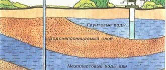
Aquifers and perched water
Often there are several aquifers underground: 2, 3 or more.
Water is retained when seeping from the surface over waterproof (mainly heavy clay) soils and accumulates in permeable (coarse, sandy) layers, which in this case are called aquifers. If an aquifer is under an aquifer, then the water in the lower aquifer is often under pressure from the overlying layers. If a pit is dug in the upper layer, water will enter it from below under pressure and rise above the level at which it originally appeared.
Such waters are called pressure waters, and the level to which they rise is called the established groundwater level. This level should be identified during engineering-geological surveys and taken into account during design.
Verkhodka is a local area of water-saturated soil limited in area, located above a waterproof lens (clays, frozen soils). As a rule, perched water has a small area and thickness, lies close to the surface, above the groundwater level. The water level in the perched waters strongly responds to the influx of atmospheric waters.
Ground water level
[Groundwater level (GWL) is the depth relative to the surface of the earth or the elevation of the free surface of the water in a well or pit. Assume a steady-state level that has not changed for at least 30 minutes]
The most accurate way to determine the groundwater level is to drill wells or dig a pit (small pit) until a free water surface (“mirror”) appears and further deepen it to 0.5-1.5 meters.
The groundwater level is not a horizontal surface and usually changes along with the relief, repeating it in a smoothed form - when the relief rises, the groundwater level also rises, but to a lesser extent.
If there are open reservoirs in the area, the groundwater level near the reservoir coincides with the mark of the daytime surface of open water and changes with it, and when moving away from the reservoir it differs up or down.
During the year, the GW also does not stand still and is constantly changing. The highest groundwater levels in latitudes with significant snow accumulation in winter are due to the infiltration of meltwater in the spring. The second, less pronounced high level is confined to the autumn rainy period. The lowest levels are observed in summer and late winter.
After the winter minimum, a sharp rise in groundwater level occurs as the snow melts. The duration of the spring maximum often does not exceed 10 days
Changes in topography during construction and soil leveling can disrupt the natural processes of redistribution and movement of groundwater, and, consequently, change the groundwater level. The main man-made disturbances are:
- Violation of the surface flow of atmospheric water - streams flowed for many years in one place, and then during construction everything was dug up, the site was raised and as a result the neighboring site began to drown in water. This phenomenon occurs quite often.
- Screening the ground surface over a large area. After this, moisture will accumulate under the closed area and the moisture content of the foundation soil will increase.
Groundwater is in constant motion, although this movement is slow and not noticeable to the human eye, it continuously occurs both vertically and horizontally towards areas of discharge (reservoirs, lowlands, rivers, etc.).
Maximum forecast (calculated) groundwater level
As calculated groundwater horizons, their highest levels should be taken in spring and autumn, and, if data are available, at the end of winter
If there is a need to obtain the calculated groundwater level, then you should use the regulatory literature. For example, “manual for SNiP 2.05.02-85 on the design of methods for regulating the water-thermal regime of the upper part of the roadbed” section 3.
The calculations are cumbersome and I will not present them here. Let me just note that when performing engineering-geological surveys, the reports usually indicate the possibility of changing the groundwater level by +/- 1.0 m from the position obtained during the survey. Less often, fluctuations take +/- 0.5 or +/- 1.5 m.
[Thus, as a rule, the calculated groundwater level should be taken as a level 1.0 meters higher than that obtained by measurements during surveys.]
Capillary rise of groundwater
[Not only soils below the groundwater level are water-saturated, but also some thickness of soils above it - this is a layer of capillary rise of groundwater]
The thickness of the layer of capillary rise of water is taken to be the distance from the level of underground water with a free surface (in the well) to the point where the moisture content of the clay soil does not exceed the moisture content at the rolling boundary.
[Humidity at the rolling boundary WP - corresponds to the humidity at which the soil loses its plasticity and turns into a solid state. The rolling out limit qualitatively corresponds to the state in which a rope rolled out from the soil to a diameter of 3 mm begins to crumble into pieces up to 1 cm long.]
The thickness of the layer of capillary rise is called the frost-risk “edge” above the groundwater level. This border depends on the composition and composition of the soil under natural conditions, and its thickness ranges from 0.3 to 3.5 m, depending on the degree of dispersion of the soil.
The capillary rise of water in soils occurs under the influence of the surface energy of mineral particles of the soil and, therefore, depends on their specific surface area. For example, in round and medium-sized sands, the specific surface area of the particles is relatively small, so in these sands there is almost no capillary rise of water and, as a result, there are no frost heave deformations (they are non-heaving soils).
Fine and silty sands consist of smaller particles compared to coarse sand, and due to the interaction of the specific surface of mineral particles with water, capillary rise in natural conditions is observed to a height of 0.3 to 0.5 m. In sandy loams, the height of capillary rise reaches from 0 .5 to 1 m, in loams - up to 1.5 m, in clays - up to 3 m.
The speed of water movement through the capillaries is much less than the rate of rise of the groundwater level and usually the capillary fringe lags behind changes in groundwater level.
Not all groundwater is of natural origin. When a water pipeline breaks, locally saturated soils swell unevenly as they freeze, causing serious damage to buildings and structures.
Artificial reduction of groundwater levels (drainage, dewatering)
For many summer residents and owners of private houses with a basement, the issue of reducing groundwater level is a very pressing one. How can high groundwater levels be dealt with? – it is necessary to do drainage.
There are different types of drainage: a horizontal system of drainage pipes, vertical drainage with wells or wellpoints, open drainage with channels and trays, and even the creation of artificial reservoirs. The outflow of water can be natural or forced - using pumps.
[Drainage in construction – translated into Russian means removal/discharge of water. Sometimes drainage refers to the removal of water from the surface, but more often it refers to the removal of groundwater. Can also be replaced by the term “water reduction”]
The main thing when creating drainage (water reduction) is to have somewhere to drain the water - you need a place where you can direct water from the drained area for a long time, without harming either the neighbors and their buildings, or the environment.
The flow of drainage water can be directed: to a drainage ditch outside the boundary of the site (if there is one), to the nearest body of water (if it does not have fishery significance), to a storm sewer (if there is one), in the direction of lower relief (if there is one, and if there is one) no neighbors).
In general, in most cases, drainage is feasible. This is a big topic that requires a separate discussion, so we will move it into a separate article.
Conclusion
Clay soils, with increasing humidity, reduce their strength qualities until they turn into a liquid state. Sands and coarse soils are less susceptible to the influence of humidity, however, groundwater also has a negative effect on them.
During the year, the GW does not stand still and is constantly changing. The highest groundwater levels are most often observed in spring and less often in autumn. The lowest levels are observed in summer and late winter.
As a rule, the calculated groundwater level should be taken as a level 1.0 meters higher than that obtained by measurements during surveys. But not only soils below the groundwater level are water-saturated, but also a certain thickness of soils above it - this is a layer of capillary rise of groundwater that can have a thickness of up to 3.5 m, depending on the type of soil.
Most groundwater is an aggressive environment for steel structures, and quite often groundwater has a destructive effect on concrete and reinforced concrete structures.
Conclusion - high-lying groundwater negatively affects the characteristics of most foundation soils and often has an aggressive effect on the foundation structures themselves, and they make construction work very difficult, so they cannot be called a welcome guest. During design and construction, this circumstance should be given due attention; perhaps you should provide for drainage at the foundation design stage.
Related Articles
Site drainage, drainage systems, water reduction
Types of dehumidification systems
There are a great variety of land drainage systems. Moreover, in different sources their classification may differ greatly from each other. In the case of drainage systems for suburban and summer cottages, it is recommended to use the simplest and most proven solutions.
Surface type drainage
Surface drainage is the simplest and most effective system. The main task is to drain the soil by draining water formed as a result of rainfall and uneven melting of snow.
Grids protect the open drainage system from large debris
A surface drainage system is constructed across the area of the site, around the house and adjacent buildings, near garage structures, warehouses and the courtyard. Surface drainage is divided into two subtypes:
- Point - in some sources referred to as local drainage. Used to collect and drain water from a certain place on the site. The main area of application is drainage of areas under drains, near entrance doors and gates, in the area where containers and watering taps are located. Often used as an emergency system if another type of drainage is overloaded.
- Linear - used to drain the entire area. It is a system consisting of receiving trays and channels arranged at a certain angle, ensuring a constant flow of water. The drainage system is equipped with filter grids and sand traps. Trays and drains are made of PVC, polypropylene, HDPE or polymer concrete.
When installing a surface drainage system, it is recommended to combine point and linear drainage. This will ensure the system operates most efficiently. If necessary, point and linear drainage can be combined with the system described below.
Deep drainage
Deep drainage is carried out in the form of a pipeline laid in places where constant drainage of the soil or lowering of the groundwater level is necessary. Drains are laid with a slope in the direction of water flow, which enters a collector, well or reservoir located outside the site.
The process of constructing deep drainage in a suburban area
For example, when installing a drainage system, when drains are laid to a depth of 0.9–1 m, the recommended distance between them is at least 9–11 m. On loamy soil under the same conditions, the step between drains is reduced to 7–9 m, and on clayey up to 4–5.5 m. More detailed data for different laying depths can be seen in the table below. Information taken from the book “Draining land for gardens” by A.M. Dumblyauskas.
When laying the pipe, the features of the terrain are observed. According to the technology, drains are laid from the highest to the lowest point on the site. If the area is relatively flat, then to impart a slope, a slope is formed along the bottom of the trench. The minimum slope level is 2 cm per 1 running meter of drainage pipe when constructing drainage in clay and loamy soil. For sandy soil, a slope of 3 cm per 1 meter is maintained.
Diagram of deep drainage device
When installing long drainage, a minimum slope along the entire length of the drainage route must be observed. For example, for a drainage system 15 m long, the minimum level difference between the starting and ending points of the route will be at least 30 cm.
If possible, it is recommended to exceed the stated slope standards. This will ensure faster drainage and reduce the risk of silting and clogging of the drain. In addition, digging a trench with a large slope is much easier than measuring 1–2 cm.
We improve the soil composition
Soil with close groundwater, and especially swamp soil, is usually quite poor, and if you manage to dry it out, you will still have to improve it before you plant plants in this area. In addition, the soil needs to be checked for pH level: it is possible that the soil on the site is highly acidic. Then before winter you will need to add from 300 to 400 g of lime per square meter or the same amount of chalk, dig everything thoroughly, and in the spring measure the pH level again, and do this until the soil becomes neutral.
Next, ideally, imported soil should be poured over the existing soil. This way you will raise the area and increase its fertility.
Next, the area needs to be dug up, mixing the soil and adding dolomite flour in the amount of 300 g per hundred square meters of land. Before planting the seedlings (if planting is in the spring, then autumn fertilization is simply an ideal option), you need to add 250-300 g of wood ash per square meter, a bucket of humus and a teaspoon with a heap of superphosphate and potassium sulfate (all this for digging , even if you have to dig up the area again).
Laying a drainage channel in an area with high groundwater
When is site drainage required?
There is high groundwater in the area, what should I do? Desperate developers often come to us with this question. Of course, it is better to take care of the problem in advance, rather than looking for additional funds after the work has begun. Remember, during construction, drainage of the site is required in the following cases:
- the lower groundwater line will be located half a meter above or below the foundation;
- the basement is planned to be placed at a depth of 1.5 m in loamy soil;
- the area is quite frozen, for example, in the Far North;
- the pressure of groundwater washes out the foundation (or, according to calculations, will wash away);
- Construction is taking place in a swampy area.
Sometimes drainage becomes necessary after construction is completed. Thus, owners of private houses, dachas and cottages should think about draining water from the site when alarm signals appear:
- cracks in the walls, warped door and window openings;
- damp smell and mold growth;
- water in the basement;
- a lot of mosquitoes and frogs on the site;
- The flora is dominated by nettle, wormwood and reeds.
In the private sector, you can drain a small area yourself, however, when dealing with capital construction, the contractor is faced with a completely different scope of work, where it is impossible to do without specialists and equipment.
Construction of artificial reservoirs
If the size and geological features of the site allow, then one of the ways to drain the site can be considered the creation of an artificial pond. This can be done when the lowest and wettest place is located on the periphery of the site. And although this method is called drainage without drainage, surface drains here can be present in the form of ditches designed as decorative or “dry” streams.
The advantage is the construction of an artificial reservoir as an element of landscape design. The disadvantage of this type of drainage is the need to regularly clean the reservoir and pump out water - the water is not flowing, accumulates, and can itself serve as a source of waterlogging. In addition, over time it begins to bloom.
How do heated substances affect the base?
The supporting foundation is clay, loam or rock. If for the latter the chemical composition is usually not very critical, then the water indicator can have a serious impact on sedimentary layers. Dry clay is strong and not prone to deformation. Saturation with liquid leads to an increase in plasticity and a sharp decrease in load-bearing properties. As an example, seasonal muddy roads in central Russia.
A fairly common phenomenon is karst cavities formed when precipitation penetrates into the limestone zone. Such caves (which have lost their strength over time) are capable of “absorbing” entire high-rise buildings.
Determining the depth of groundwater
There are many terms used by surveyors to refer to groundwater, and one of them is a site groundwater map or zoning. If you have such information, it will be much easier for you to arrange your own site, and you will be able to easily understand whether the site needs to be drained in certain places, backfilled, where you can build and where you should not plant even plants with a shallow root system.
Unfortunately, in our time, such geological studies are quite expensive procedures that require the conclusion of contracts, waiting in line, and certain costs. But there are always smarter ways to get the necessary information that will help in the future.
For the greatest accuracy of the information obtained, it is recommended to use effective methods in the off-season, when the amount of precipitation is maximum. This is spring or autumn, with melting snow or frequent rains, respectively.
Geobotanical method for determining groundwater level
Here it is worth working hard and paying attention to the consistency of the growth and development of plants depending on the water level and some features of the area. For this purpose, special tables are used, which include plants that are most common on certain soils and that develop differently on soil with varying degrees of moisture.
The method is quite interesting, but difficult for beginners, and the worst thing is that it can take a lot of free time, which is often not enough.
Checking the water level in wells
The ground water level, or rather even seasonal fluctuations, can be determined by the marks inside the well. Such marks are always present, since water leaves a certain mark on concrete. It is necessary to determine the highest point, the water level at the time of testing, the level during hot weather in the summer, and also note how far the marks are from ground level. It is also a complex job, which is not always clear to beginners in geological exploration, even if it is an amateur one. But the method is in demand, especially when everything needs to be done quickly and inexpensively.
Drilling a well to determine groundwater level
The fastest and easiest way from all aspects, except technical. But if the farm has a simple drill for the earth, or it is available as an attachment on your mini-tractor or even a tractor, then everything becomes much simpler.
It is necessary to drill a well in the soil at least two meters deep and monitor it for 3-5 days. If liquid gradually rises at the bottom of the well, this may be an alarm bell and mean that the GWL is high and may increase with precipitation. But if after 3-5 days the well is dry, then there is nothing to fear. In large areas, it is customary to drill more than one well in order to accurately determine where water may be present, and where it will definitely not cause any problems.
High water level in the ground: main problems
If any research on this issue has led you to the conclusion that you still need to worry, we recommend that you be patient, but do not delay work to reduce the water level, as water can cause serious harm.
Harm to the septic tank, sewerage system, outdoor toilet
The high level of groundwater, which is constantly rising due to precipitation, can periodically rise and flood the outdoor toilet, septic tank and sewerage system on the site. These are serious problems, because water:
- in an outdoor toilet - this is a real help in the emergence of additional dangers in terms of infection, unpleasant odors and destruction of the structure itself and its foundation;
- around sewer pipes running in the soil without any protection - additional causes of corrosion and shortening the life of a rather expensive system;
- around the septic tank - problems with its cleaning, refilling of levels and chambers, inhibition of the flow of purified water into the ground, and so on. Much the same can be said about a cesspool, in which water will cause even more trouble.
Harm to the cellar and garage pit
Having built a cellar, a basement similar to a thermos greenhouse, a thermos greenhouse itself, or an inspection hole in a garage in an area with a high groundwater level, we doom ourselves to serious problems in the future, because every season there is the possibility of encountering additional moisture, which is not needed in these places .
- In the cellar and basement, water will interfere with the storage of vegetables, fruits and seams, leading to rotting of food and destruction of the buildings themselves;
- In the inspection pit, where the tool is often left, humidity can have a very negative effect on it. In addition, it will not allow you to work normally in the garage, and will also have a negative impact on the foundation of the building;
- Speaking from a thermos greenhouse, we can say for sure that if the maximum moisture penetrates inside during the active period of operation, for example, in the spring, this will lead to significant losses.
Foundation problems
A high level of water in the ground and the foundation are generally incompatible things, which is why we constantly protect the foundation of buildings from moisture with waterproofing. Just imagine, there is no longer moisture from the ground, but direct contact with liquid... this can lead to serious troubles when the foundation bursts, partially changes level, pulls the walls along with it, forming cracks on them. It is very difficult and expensive to repair the foundation, basement and walls by tightening the walls of the house with special metal structures and pouring glass or other materials under the foundation.
Well problems
Groundwater penetrates almost everywhere, and therefore easily replenishes the level of wells. If there is one on your site, and there is a cesspool or street toilet nearby, and a high water level is also connected to the complex, you will no longer be able to drink from the well. Depending on the type of groundwater, composition and other characteristics, it is likely that the water from the well cannot be used at all. For example, it has a high level of salt, which means that it is undesirable to feed birds and pets with it, it is inconvenient to wash, since such water does not remove soap products from fabrics, and so on.
Problems with plants
There is an opinion that groundwater does not have as negative an effect on the plant as its frequent stagnation and maintenance. That is, a constantly “floating” groundwater level does not harm trees, shrubs and other plants in the garden, but the high level that sets in spring or autumn often has a very detrimental effect. A liquid with unknown content, coming from, say, a car wash or repair shop, some laboratory with chemicals and other dangerous places, stagnates in one place and poisons the plants through the root system. But this is in rare cases; more often it happens that the plants simply get wet due to oversaturation with moisture!
Types and components of systems
There are three main types of drainage systems:
- superficial;
- deep;
- backfill
They all have their own advantages and disadvantages. A surface drainage system looks like a regular ditch on the surface of the earth. It is used to remove excess moisture that has formed after melting snow or heavy rainfall. Often the surface system is combined with a storm drain or storm sewer. The purpose of the latter is to collect and remove precipitation. It is usually equipped with linear and point water collectors.
A deep or closed drainage system is recognized to drain excess through a system of pipes and wells. Usually it is turned to when there is a threat of flooding of the garden with groundwater or heavy rainfall. The system consists of pipes, a well that acts as a drainage system, and a pump for pumping out water. Initially, trenches are dug, then pipes are installed in them, and then wells are built. The pipeline is covered with soil on top, on which you can even grow something. The insides of the pipes are equipped with crushed stone, sand, gravel and geotextiles.
The backfill system works in the same way as the deep one. However, no pipes are used in its construction: only drainage material is needed. It is used to remove the effects of excessive precipitation and is selected when the area of the site is quite small. The disadvantage of this system is that without dismantling it is impossible to carry out repair work or clean the system.
Drainage structures are divided into open and closed varieties. The first looks like a sequence of ordinary ditches, grooves, and trays. For the second, perforated pipes are placed in the trenches or soil is filled in, demonstrating outstanding filtration capabilities. Externally, this option is more aesthetically pleasing, but the receiving hole here is usually much narrower and smaller.
Artificial reduction
There is another way to reduce the water level, but it is applicable only at the beginning of foundation construction. The liquid is sucked out through dug wells using deep pumps. This option is especially often used if water suddenly begins to appear during construction. This way the soil dries out well and the buildings are no longer in danger.
Sewage device
If you are faced with the problem of high groundwater levels, be prepared for the fact that it will not be easy to install a sewer system in your house. It will be necessary to solve several difficulties that may be encountered when installing a septic tank. If there is too much moisture, it can cause the contents of the drain to simply leak out through the house's toilet or bathtub. The device may leak, burst, or experience some other malfunction. Difficulties may also arise when installing a septic tank. Be prepared to build a ditch while standing waist-deep in water. It will be extremely difficult to concrete the container. It is important to understand that if the sewer system is damaged, groundwater can carry sewage through the channels and the dirt will end up in wells and drinking water pipes. Therefore, the installation of a septic tank must be approached with all responsibility; errors during installation can bring a lot of trouble in the future.
It is important to understand that if the sewer system is damaged, groundwater can carry sewage through the channels and the dirt will end up in wells and drinking water pipes.
Therefore, the installation of a septic tank must be approached with all responsibility; errors during installation can bring a lot of trouble in the future.